From Devil's Den to Little Round Top, it's an introduction to pivotal points in the Civil War visitors to the atmospheric town of Gettysburg and the associated battlefield will get on a driving or walking tour.
Part of the Independence Creek trail system. Upper trailhead on Road 2378. Best of the two trails off Faset Peak.
Details
Length:
3.6 miles
Difficulty:
Intermediate
Time:
1 - 2 hours
Trailhead Elevation:
1840
Usage:
Light
Useful Map(s):
USGS: Faset Peak
Map + Directions
Basic Directions
From Coeur d'Alene, Idaho take U.S. 95 north to Bunco Road. Follow Bunco Road east into the National Forest where the road becomes Forest Road 332 (FR332). Continue on FR332 to it's junction with FR2378. Follow FR2378 to the Trail 416 upper trailhead on the right side of the road. The upper end of Trail 416 is close by on the opposite side of the road. From Prichard, Idaho follow FR208 (N.F. Coeur d'Alene River road) north. After it's junction with FR1554 it becomes FR6310. At it's junction, take FR3099 north near Independence Creek. From FR3099 take FR205 east to it's junction with FR332. Take FR332 south (left) to FR2378 and turn left. Follow FR2378 to the Trail 416 upper trailhead on the right side of the road. The lower end of Trail 416 can be accessed from Trail 22.
Below are the Free Visitor Guides for Coeur d'Alene. More Visitor Guides are available in Pennsylvania. Click here to view them all!
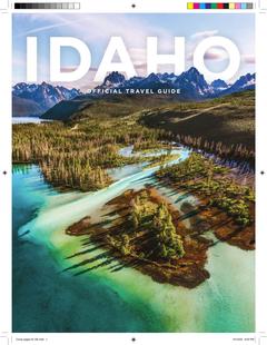
Visit Idaho Idaho
Visit Idaho
IdahoStart planning your Idaho adventure. Vacation is more than just scenery; it’s about making life long memories. Download or order the free Idaho Travel Guide here. Request this Free Visitor GuideRequested!You're all set! Complete the form below to receive your guides by mail.
Switch to Mobile Browser Mode
We offer a compact version of Go-Pennsylvania for mobile users, allowing you to access just the information you need on the road. Of course, you can still use the full version of Go-Pennsylvania on your mobile device just as you can on your desktop.