


Contact Info
- Phone 1:
- 814-723-5150
- Phone 2:
- 814-726-2710
Description
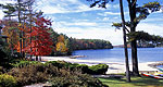
This 15.8 mile long trail begins at the long loop of the Black Cherry National Recreation Interpretive Trail located at Twin Lakes Recreation Area and travels west to join with the North Country National Scenic Trail.
Details
Additional Details:
Watch the informational signs...this trail offers challenges to a wide range of skill levels as it climbs from Hoffman Run at the Twin Lakes Recreation Area over the plateau, and then drops into the headwaters of Wolf Run on its way to Tionesta Creek. Spots along Wolf Run will be wet. After crossing Tionesta Creek and then Crane Run, a designated Wilderness Trout Stream, the trail then climbs into the Tionesta National Scenic Area. The North Country National Scenic Trail junctions with the Twin Lakes Trail in the scenic area. Hikers then have the opportunity to move north or south on the cross-forest trail. The Twin Lakes Trail is the second longest trail on the forest, and was intended to provide a link to the cross-forest North Country National Scenic Trail while allowing hikers to utilize the parking and recreational facilities available at the newly remodeled Twin Lakes Recreation Area. Enjoy!
Fishing for small native brookies and brown trout can be done in Wolf Run, Tionesta Creek and Crane Run. The Pennsylvania Fish and Boat Commission recognizes Crane Run as a designated Wilderness Trout Stream. Look for wildlife along the way. You will be traveling through some of the more heavily developed portions of the forest; oil and gas activities will be evident.
The trail is marked with off-white markers. Forest trails policy prohibits the use of saddle, pack or draft animal on hiking trails.
The skill level of these hiking trails are more difficult and you should be in good health to enjoy them. We encourage you to hike with at least one other person and to leave your itinerary with friends so they''ll know where to look if you don''t return on time or need assistance.
These trails are open for winter hiking. Remember to dress in layers appropriate for the weather conditions. Be aware that these trails are used heavily in the late fall and spring by hunters. It is a good idea to wear bright fluorescent colored clothing if hiking during these time periods.
These trails are open for winter hiking. Remember to dress in layers appropriate for the weather conditions. Be aware that these trails are used heavily in the late fall and spring by hunters. It is a good idea to wear bright fluorescent colored clothing if hiking during these time periods.
The nearest hospital is located in Kane (north on SR 321). The nearest telephone is also located in Kane.

